

Bushfire Management Plan (BMP)
A Bushfire Management Plan (BMP) outlines the specific measures required to reduce bushfire risk on your property, based on an assessment of vegetation, slope, access, and fire behaviour. It is typically required for planning approvals in bushfire-prone areas and ensures compliance with State Planning Policy 3.7 and associated Guidelines.

What is a BMP ?
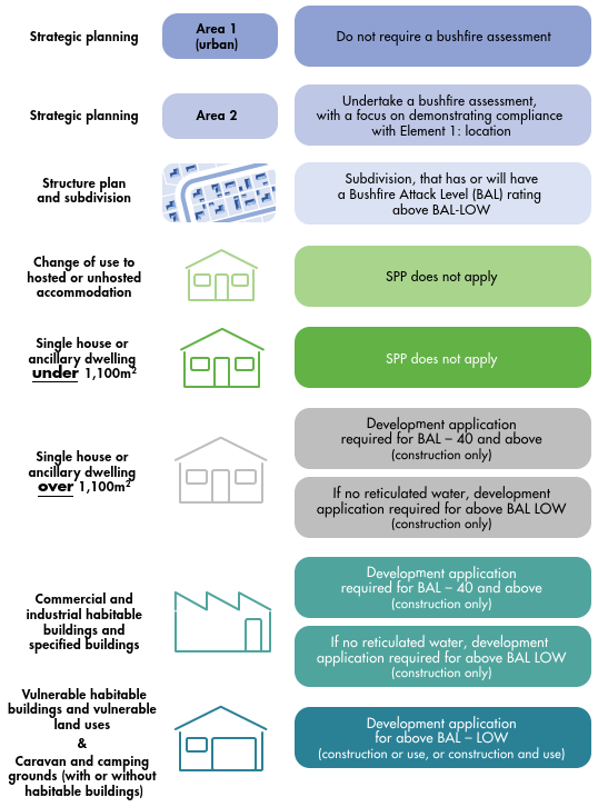
When do I need a BMP, and when does Bushfire Planning (SPP 3.7) Apply?
What does a BMP assess?
What to do once you receive your BMP
A Bushfire Attack Level (BAL) is a rating that identifies the potential level of bushfire risk to a building based on the surrounding environment. The assessment considers key site features such as slope, vegetation type and proximity, and local fire weather conditions. From this, a BAL rating is assigned, ranging from BAL-LOW (low risk) to BAL-FZ (Flame Zone, extreme risk).
Each category corresponds with specific construction requirements outlined in AS 3959 – Construction of Buildings in Bushfire-Prone Areas, designed to improve a building’s ability to withstand bushfire impacts.
In Western Australia, State Planning Policy 3.7 (SPP 3.7) and its Guidelines help manage bushfire risk during land use planning and development. A Bushfire Management Plan (BMP) is generally required when a proposal must demonstrate compliance with the bushfire protection criteria outlined in the Guidelines.
They apply if your property is within a designated bushfire-prone area (check the Map of Bush Fire Prone Areas) and your proposal will:
Increase the number of people living, working, or visiting the site
Intensify land use (e.g. building more houses, businesses, or accommodation)
Potentially increase the bushfire risk to your land or neighbouring properties
SPP 3.7 may be triggered for:
New housing developments or subdivisions
Commercial or industrial developments
Tourist accommodation like caravan parks or campgrounds
Changes to planning documents like structure plans or local planning strategies
A Bushfire Management Plan (BMP) assesses how a proposed development will minimise bushfire risk and meet planning requirements. It typically covers:
Water Supply for Firefighting: Ensures adequate water is available via on-site tanks (usually fitted with CFA-compliant fittings) or access to mains-connected hydrants within a set distance of the property.
Property Access: Confirms that driveways and emergency access routes meet minimum standards—typically a 6 m wide trafficable surface, with turning areas and vertical clearance to allow emergency vehicles to enter and exit safely.
Asset Protection Zones (APZs): Establishes minimum setbacks between vegetation and buildings, often requiring managed areas around structures to reduce bushfire impact and radiant heat exposure.
All elements covered in a BAL: This is the vegetation assessment. View this page for a detailed description of a BAL Assessment.
These elements work together to ensure the site meets the bushfire protection criteria and achieves a risk level acceptable under SPP 3.7 and the Guidelines.
When you receive your Bushfire Management Plan (BMP), it’s important to review it carefully. In most cases, the BMP will outline required actions that must be completed before you can apply for a Building Licence.
These actions are typically summarised in a compliance table within the BMP and may include:
Establishing and maintaining an Asset Protection Zone (APZ)
Installing a dedicated firefighting water supply (e.g. tank with fittings or access to hydrants)
Ensuring driveway design meets access requirements (e.g. 6 m trafficable surface)
Upgrading or maintaining vegetation setbacks or fencing
Noting ongoing responsibilities for vegetation management
The specific actions will depend on the type and scale of development, and must usually be addressed before construction begins or as a condition of approval.
Need a BMP? Contact us for a free quote!